SRM – DOC ALERT – HURRICANE MATTHEW

October 7, 2016 by Medigroup
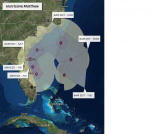
The western eyewall of Category 3 Hurricane Matthew is approaching Cape Canaveral, Florida. The center of the hurricane is about 25 miles east of Cape Canaveral and it continues to move toward the northwest.
Matthew is expected to maintain Category 3 intensity through early this morning as it moves parallel to the eastern coast of Florida. Landfall is still possible near Cape Canaveral early this morning. However, the ultimate outcome is the center stays just offshore. How close it passes to Florida will determine the degree of impacts. Wind gusts along the central Florida coast can exceed 100 mph as the western eyewall moves overhead. This will lead to widespread power outages, damage to trees and some structures. The highest threat of these extreme winds going forward will be from just south of Cape Canaveral to Daytona Beach.
A storm surge of 6-10 feet will inundate large sections of areas near the coast causing further damage and a threat to life. Rainfall amounts of 4-8 inches are expected and lead to freshwater flooding. Wind gusts will exceed 50-60 mph farther inland across central and northeastern Florida, including the Orlando metro area. Matthew will turn north later today, then north-northeast tonight and spread powerful winds and heavy rain into coastal Georgia and South Carolina. A landfall along the South Carolina coast is possible before it turns more toward the northeast then east during the day Saturday. It will be close enough to North Carolina for high winds, heavy rain and rough surf to impact eastern parts of that state, especially over the southern Outer Banks and over the southeast coastal areas, including the city of Wilmington.