SRM – DOC ALERT UPDATE – HURRICANE MATTHEW

October 3, 2016 by Medigroup
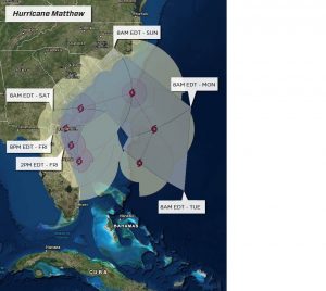
Hurricane Matthew is currently a dangerous Category 4 moving north in the Caribbean Sea at 6 mph. Matthew will pose a significant threat to life and property across parts of Jamaica, Hispaniola, eastern Cuba and the Bahamas this week. While current computer models keep Matthew east of Florida, there is still enough uncertainty in the global ensembles that direct impacts in Florida cannot be ruled out. In addition, it is still too soon to determine whether, or how Matthew could affect the remainder of the U.S. east coast. We will continue to monitor this tropical system and send updated DOC Alerts as the forecast develops. In the meantime, if you are in need of our services please call the MediGroup Emergency SRM Hotline: 888.243.5760.
FORECAST:
Matthew is a dangerous Category 4 hurricane with maximum-sustained winds of 130 mph and is moving north at around 6 mph. Matthew will pose a significant threat to life and property across parts of Jamaica, Hispaniola, eastern Cuba and the Bahamas this week. Matthew is expected to remain at least a Category 4 hurricane today and tonight, although some weakening to a high-end Category 3 hurricane is possible.
Matthew will pass close to the western tip of the Tiburon Peninsula of Haiti late on Monday night or early Tuesday morning. This will bring the eastern eyewall and the most powerful winds within the storm to that area. Maximum-sustained winds of 110-130 mph are expected with higher gusts. This will cause widespread power outages, major damage to most, if not all structures, and complete destruction of weaker structures. Tropical storm-force winds with gusts past 60 mph will impact eastern Jamaica late on Monday into Monday night. This can lead to power outages and some damage to structures. Portions of the southwestern Tiburon Peninsula of Haiti will experience a storm surge of 10-15 feet and perhaps higher. Conditions across eastern Cuba will deteriorate on Tuesday as Matthew gets closer to the eastern portion of the island.
On Tuesday, Matthew is expected to be a Category 3 hurricane, possibly a Category 4 storm. The center of Matthew will reach far eastern Cuba late on Tuesday or Tuesday evening and pass over the eastern tip of the island on Tuesday night. During that time, sustained winds of 110-130 mph with higher gusts are expected. This will cause widespread power outages, major damage to most, if not all structures, and complete destruction of weaker structures. A storm surge of at least 10-15 feet, possibly higher, will impact the south-facing shore of far eastern Cuba as Matthew approaches, then makes landfall.
Matthew will approach the southern Bahamas early Wednesday, probably as a Category 3 hurricane, perhaps a high-end Category 2 storm. Matthew is expected to turn toward the northwest and move into the central Bahamas on Wednesday night or Thursday morning. At that time, Matthew will either be a Category 2 or 3 hurricane. Either way, the combination of hurricane-force winds and a storm surge of 8-15 feet will cause major damage across the southern and central Bahamas. Matthew will then impact the northern Bahamas on Thursday into Thursday night.
The extreme rainfall with Matthew will pose another set of problems. Rainfall amounts of 12-24 inches, perhaps more, are expected across parts of Haiti and eastern Cuba. This will cause catastrophic flooding and mudslides across those areas. Heavy rain of 8 inches or more can bring flooding and mudslides to parts of eastern Jamaica. Over a foot of rain is expected across parts of the Bahamas from Matthew.
There remains a concern that the system could take a track farther to the west, which would bring it closer to Florida and, ultimately, along the length of the southeastern U.S. coast late this week and into the weekend. Direct impacts to the United States from Matthew remain uncertain. However, unusually rough surf and strong rip currents are likely across the southeastern U.S. coast toward later this week and into the weekend. The wind field from Matthew will grow larger later this week and it could get close enough to the southeastern U.S. coast to bring tropical storm-force gusts past 40 mph to the Atlantic Coast of Florida as early as Thursday night and coastal areas of the Carolinas as early as Friday night.